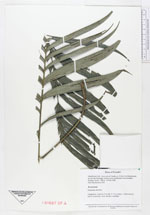
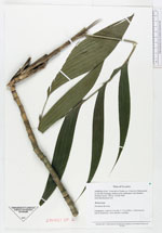
| Collector | Borchsenius, F. |
| Number | 218 |
| Collected with | |
| Country | Ecuador |
| Subpart | ESMERALDAS |
| County | |
| Locality | Cerro de la Tunda, ca. 15 km E of Maldonado on the Río Santiago, half an hour upstreams from Borbon. Primary forest |
| Coordinates | 1° 1' N 78° 55' W |
| Minimum elevation (m) | 200 |
| Maximum elevation (m) | 200 |
| Start date | 1994/02/23 |
| End date | 1994/02/23 |
| Family | Arecaceae |
| Identification | Geonoma deversa (Poit.)Kunth |
| Determined by | |
| Identification qualifier | |
| Field notes | Caespitose, stems to 3 m tall, 1-1.5 cm diam. Inflorescence twice branched, with slender rachillae |
|