AAU Herbarium Database |
| New Search Modify Search |
| Collector | Wood, E. W. |
| Number | 4875 |
| Collected with | D. E. Boufford |
| Country | USA |
| Subpart | Georgia |
| County | |
| Locality | SE of the town of Stillmore, 3.7 km (2.3 miles) SE of the Emanuel County line on Stillmore Road. Quercus laevis - Pinus taeda forest with Ceratiola, Opuntia, Cnidoscolus and Satureja |
| Coordinates | |
| Minimum elevation (m) | 40 |
| Maximum elevation (m) | 40 |
| Start date | 1988/05/30 |
| End date | 1988/05/30 |
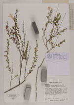
| Family | Lamiaceae |
| Identification | Clinopodium coccineum Kuntze |
| Determined by | Christian Braeuchler |
| Identification qualifier | |
| Field notes | Shrubs to 1 m tall, scattered in the understory. Flowers scarlet |
| |
| New Search Modify Search |