AAU Herbarium Database |
| New Search Modify Search |
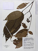
| Collector | Vogel, E.F.de |
| Number | 7644 |
| Collected with | |
| Country | Indonesia |
| Subpart | Jawa |
| County | |
| Locality | West Jawa, road pelabuhan Ratu- Kiara - Bagbagan, c. 17 km past Kiara. Somewhat disturbed primary forest c. 30 km high, with some undergrowth of herbs. Terrain level, rather deep clayey volcanic soil |
| Coordinates | |
| Minimum elevation (m) | 300 |
| Maximum elevation (m) | 300 |
| Start date | 1985/09/16 |
| End date | 1985/09/16 |
| Family | Leeaceae |
| Identification | Leea indica Merr. |
| Determined by | P.C. van Welzen |
| Identification qualifier | |
| Field notes | Solitary shrub 1.5 m high. Flower ochrish yellow, calyx tinged red. nflorescence stalks bright red. Leaves above green, below pale green to violet |
| |
| This record has no coordinates. Display map with the 27 georeferenced records of Leea indica in the AAU Herbarium Database. |
| New Search Modify Search |