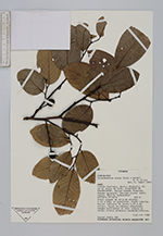
| Collector | Rubio, D. |
| Number | 249 |
| Collected with | |
| Country | Ecuador |
| Subpart | Napo |
| County | |
| Locality | Cantón Orellana. Sector Huashito, 20 km al norte de Coca. Propiedad de PALMORIENTE. Bosque húmedo Tropical. Bosque primario, terreno plano; suelo negro, fértil, Hydrandept. |
| Coordinates | 0° 20' S 77° 5' W |
| Minimum elevation (m) | 250 |
| Maximum elevation (m) | 250 |
| Start date | 1989/11/03 |
| End date | 1989/11/21 |
| Family | Annonaceae |
| Identification | Ruizodendron ovale (Ruiz & Pav.)R.E. Fries |
| Determined by | D. Rubio |
| Identification qualifier | |
| Field notes | Arbol grande de 40 m de altura; 1.20 m DAP; en pendiente. Fuste regular. Raices tablares de hasta 1.50 m de altura. Hojas coriáceas, flexibles; verdes brillantes el haz, claras el envés. Frutos globosos verde-brillantes. |
|
 Other records of Ruizodendron ovale