| Collector | Neill, D. |
| Number | 9061 |
| Collected with | |
| Country | Ecuador |
| Subpart | Napo |
| County | |
| Locality | Cantón Archidona. South slopes of Volcán Sumaco. Hollín-Loreto road, km 31. Challua Yacu. Primary forest on ently sloping, well drained terrain; volcanic soils. Premontane rain forest |
| Coordinates | 0° 43' S 77° 39' W |
| Minimum elevation (m) | 1200 |
| Maximum elevation (m) | 1200 |
| Start date | 1989/10/18 |
| End date | 1989/10/18 |
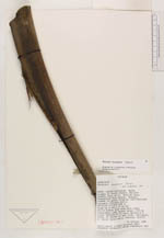
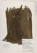
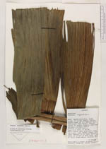
| Family | Arecaceae |
| Identification | Wettinia maynensis Spruce |
| Determined by | R. Bernal |
| Identification qualifier | |
| Field notes | Tree 12 m ta--; 15 cm DBH. Stilt roots, with prominent warty lenticels. Leaf sheath green, 170 cm long. Petiole 25 cm long. Rachis 4 m long. 32 pinnae on each side. Inflorescence with stiff brown hairs. |
|