AAU Herbarium Database |
| New Search Modify Search |
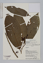
| Collector | Neill, D. |
| Number | 8976 |
| Collected with | D. Rubio |
| Country | Ecuador |
| Subpart | Pastaza |
| County | |
| Locality | Vía Auca, 115 km S of Coca, near Río Tigüino. Entrance road to PETRO-CANADA oil well site; km 4-5 of new road. Tropical Moist Forest. Primary forest; trees felled for road. |
| Coordinates | 1° 15' S 76° 55' W |
| Minimum elevation (m) | 320 |
| Maximum elevation (m) | 320 |
| Start date | 1989/05/04 |
| End date | 1989/05/04 |
| Family | Annonaceae |
| Identification | Anaxagorea phaeocarpa Mart. |
| Determined by | Paul Maas |
| Identification qualifier | |
| Field notes | Tree 8 m tall; understory in forest. On alluvial soil near river. Branches all horizontal. Calyx with yellow-brown tomentum. |
| |
 Other records of Anaxagorea phaeocarpa Other records of Anaxagorea phaeocarpaThe map displays only records from the Aarhus Herbarium Database. The records may not represent the full distribution of Anaxagorea phaeocarpa |
| New Search Modify Search |