AAU Herbarium Database |
| New Search Modify Search |
| Collector | Neill, D. |
| Number | 8828 |
| Collected with | Fernando Hurtado |
| Country | Ecuador |
| Subpart | Pastaza |
| County | |
| Locality | Via Auca, 115 km S of Coca, 10 km S of Napo-Pastaza border; near Río Tiguino. Tropical Moist Forest on low hills. Primary forest; trees felled for road construction. Entrance road to PETROCANADA oil well site. |
| Coordinates | 1° 15' S 76° 55' W |
| Minimum elevation (m) | 320 |
| Maximum elevation (m) | 320 |
| Start date | 1989/01/26 |
| End date | 1989/01/31 |
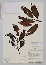
| Family | Myristicaceae |
| Identification | Otoba parvifolia (Markgr.)A.H.Gentry |
| Determined by | Tatiana Jaramillo |
| Identification qualifier | |
| Field notes | Tree 25 m tall; trunk 30 cm DBH. Forest canopy. Watery red sap. Flowers yellow. Dioecious; female flowers. |
| |
| Display all 84 georeferenced records of Otoba Otoba parvifolia |
| New Search Modify Search |