AAU Herbarium Database |
| New Search Modify Search |
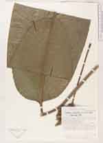
| Collector | Neill, D. |
| Number | 6471 |
| Collected with | W. Palacios & J. Zaruma |
| Country | Ecuador |
| Subpart | Napo |
| County | |
| Locality | 8 km rio abajo de Puerto Misahualli, por el Rio Napo |
| Coordinates | 1° 4' S 77° 36' W |
| Minimum elevation (m) | 450 |
| Maximum elevation (m) | 450 |
| Start date | 1985/05/27 |
| End date | 1985/05/29 |
| Family | Marantaceae |
| Identification | Goeppertia capitata (Ruiz & Pav.) Borchs. & S.Suárez |
| Determined by | F.Borchsenius |
| Identification qualifier | |
| Field notes | Bosque muy humedo tropical. Suelo limo aluvial fertil, en terraza del rio. Bosque secundario y margenas. Hierba en sombra del sotobosque. Peciolo y pedunculo erectos, ambos hasta 2 m de largo. Bracteas verdes. Flores blancas |
| |
 Other records of Goeppertia capitata Other records of Goeppertia capitataThe map displays only records from the Aarhus Herbarium Database. The records may not represent the full distribution of Goeppertia capitata |
| New Search Modify Search |