| Collector | Neill, D. |
| Number | 16909 |
| Collected with | Camilo Kajekai |
| Country | Ecuador |
| Subpart | Zamora-Chinchipe |
| County | |
| Locality | Cordillera del Cóndor. The Machinaza plateau, one of the highest-elevation Hollín sandstone plateaus in the Cóndor region. About 500 m west of the Ecuador-Peru international border, near end of the trail from Paquisha Alto military post. Bare sandstone substrate, or quartzsite sand derived therefrom, very nutrient-poor. Dwarf scrub vegetation, dominated by scrubs to about 1.5 m tall, with occasional small trees to 4 m tall. Vegetation slowly recovering from an extensive burn about 20 years previously, with charred woody stems in abundance on ground |
| Coordinates | 3° 54' 6'' S 78° 28' 57'' W |
| Minimum elevation (m) | 2315 |
| Maximum elevation (m) | 2315 |
| Start date | 2009/06/23 |
| End date | 2009/06/23 |
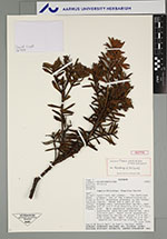
| Family | Melastomataceae |
| Identification | Miconia machinazana C.Ulloa & D.A.Neill |
| Determined by | |
| Identification qualifier | |
| Field notes | Small, profusely branched shrub about 50 cm tall, never attaining as tall as 1 meter. Leaves revolute, with light brown pubescence beneth, in strict decussate arrangement. Corolla pale yellow. Mature fruits pink-reddish, somewhat oblate or nearly globose, fleshy |
|