| Collector | Neill, D. |
| Number | 16132 |
| Collected with | W. Quizhpe |
| Country | Ecuador |
| Subpart | Zamora-Chinchipe |
| County | |
| Locality | Yantzaza. Centinela del Cóndor. Cordillera del Cóndor. Machinaza plateau summit area. Adjacent to obelisk-shaped border marker, at end of trail from upper Paquisha military post, precisely at Ecuador-Peru border. Nearly level sandstone plateau with low scrub vegetation; charred stems and regrowth indicate that area was burned about 15 years previously. |
| Coordinates | 3° 53' 50'' S 78° 28' 49'' W |
| Minimum elevation (m) | 2420 |
| Maximum elevation (m) | 2420 |
| Start date | 2008/03/15 |
| End date | 2008/03/15 |
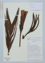
| Family | Arecaceae |
| Identification | Geonoma trigona (Ruiz & Pav.) A.H.Gentry |
| Determined by | A. Henderson (NY) |
| Identification qualifier | |
| Field notes | Small palm with erect stem to 70 cm tall. Leaves undivided. Inflorescence borne below leaves. Locally common in shrubby vegetation on sandstone plateaus. |
|