AAU Herbarium Database |
| New Search Modify Search |
| Collector | Neill, D. |
| Number | 15313 |
| Collected with | NSF Dendrology course |
| Country | Ecuador |
| Subpart | Zamora-Chinchipe |
| County | |
| Locality | Nangaritza Cantón. Cordillera del Cóndor region, upper Río Nangaritza. "Area de Conservación Los Tepuyes", on upper portion of sloping sandstone plateau southwest of Las Orquídeas. Dense, wet forest, in and near 1-hectare forest inventory plot, "Nangaritza Upper Sandstone Plateau Plot". |
| Coordinates | 4° 15' 32'' S 78° 41' 4'' W |
| Minimum elevation (m) | 1620 |
| Maximum elevation (m) | 1620 |
| Start date | 2006/11/06 |
| End date | 2006/11/06 |
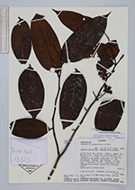
| Family | Annonaceae |
| Identification | Guatteria punctata (Aubl.)Howard |
| Determined by | Name updated acc. to Tropicos |
| Identification qualifier | |
| Field notes | Tree 8 m tall. Flowers yellowish to green. |
| |
| Display all 47 georeferenced records of Guatteria Guatteria punctata |
| New Search Modify Search |