AAU Herbarium Database |
| New Search Modify Search |
| Collector | Neill, D. |
| Number | 10295 |
| Collected with | G. Tipaz & A. Dik |
| Country | Ecuador |
| Subpart | Napo |
| County | |
| Locality | Aguarico. Huaorani Ethnic Reserve. Maxus petroleum pipeline road, under construction. Kilometer 68, 10 km SW of Río Tivacuno. Primary forest on hills, red clay soil. Tropical Moist Forest |
| Coordinates | 0° 49' S 76° 26' W |
| Minimum elevation (m) | 240 |
| Maximum elevation (m) | 240 |
| Start date | 1993/12/13 |
| End date | 1993/12/13 |
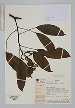
| Family | Araliaceae |
| Identification | Dendropanax Decne. & Planch. |
| Determined by | |
| Identification qualifier | |
| Field notes | Tree 20 m tall. Subcanopy of forest |
| |
| Display all 123 georeferenced records of Dendropanax Dendropanax |
| New Search Modify Search |