AAU Herbarium Database |
| New Search Modify Search |
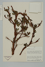
| Collector | Smith, D.N. |
| Number | 9270 |
| Collected with | L.Sánchez, H.Vidaurre |
| Country | Peru |
| Subpart | Ancash |
| County | |
| Locality | Huayalas. Huascarán National Park, Quebrada Santa Cruz between Hatunquiswar and Lago Santa Cruz Chico. |
| Coordinates | 8° 55' S 77° 40' W |
| Minimum elevation (m) | 4100 |
| Maximum elevation (m) | 4100 |
| Start date | 1985/01/16 |
| End date | 1985/01/16 |
| Family | Rosaceae |
| Identification | Polylepis incana H.B.K. |
| Determined by | T.E. Boza E. |
| Identification qualifier | |
| Field notes | Shrubland, grassland, and marshy areas in bottoms. Shrub 2,5, bark reddish, papery, multilayered; lvs white below; infl pendant, green. Full crowned shrub, almost spherical. "Quengua, queñua, queñual". |
| |
| Display all 94 georeferenced records of Polylepis Polylepis incana |
| New Search Modify Search |