AAU Herbarium Database |
| New Search Modify Search |
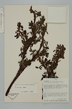
| Collector | Smith, D.N. |
| Number | 9215 |
| Collected with | L.Sánchez, H.Vidaurre |
| Country | Peru |
| Subpart | Ancash |
| County | |
| Locality | Yungai. Huascarán National Park, morococha at largest lake. |
| Coordinates | 8° 55' S 77° 35' W |
| Minimum elevation (m) | 4550 |
| Maximum elevation (m) | 4550 |
| Start date | 1985/01/15 |
| End date | 1985/01/15 |
| Family | Rosaceae |
| Identification | Polylepis sericea Wedd. |
| Determined by | T.E. Boza E. |
| Identification qualifier | |
| Field notes | Polylepis woods and steep slopes with tussock grassland. Tree 3 m., 25 cm. DBH; trunk very contorted; bark reddish, multilayered, papery; lvs white pubescence; fls green; infl pendant. "Quengua, queña". Possibly at hybrid. |
| |
| Display all 56 georeferenced records of Polylepis Polylepis sericea |
| New Search Modify Search |