AAU Herbarium Database |
| New Search Modify Search |
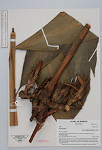
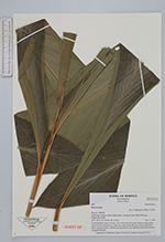
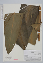
| Collector | Magintan, D. |
| Number | 580 |
| Collected with | B. Albaek |
| Country | Malaysia |
| Subpart | SABAH |
| County | |
| Locality | Lahad datu. Danum Valley Field Centre, secondary forest. Mixed Primary Dipterocarp forest. |
| Coordinates | 4° 40' N 117° 29' E |
| Minimum elevation (m) | 150 |
| Maximum elevation (m) | 150 |
| Start date | 1998/11/04 |
| End date | 1998/11/04 |
| Family | Zingiberaceae |
| Identification | Hornstedtia |
| Determined by | D. Magintan (UMS), 11/4/98 |
| Identification qualifier | |
| Field notes | Terrestrial herb, about 3 m tall, 1 m to first leaf, stilt rooted, rhizome adscending about 10 cm to each shoots, red at base, stem yellowish green; leaves dark green above, mid green lower; inflorescence red, flower red, labellum and laterall petalred, young shoot green. |
| |
 Other records of Hornstedtia Other records of HornstedtiaThe map displays only records from the Aarhus Herbarium Database. The records may not represent the full distribution of Hornstedtia |
| New Search Modify Search |