AAU Herbarium Database |
| New Search Modify Search |
| Collector | Pearsall, D.M. |
| Number | 1097 |
| Collected with | |
| Country | Ecuador |
| Subpart | Manabi |
| County | |
| Locality | San Isidro area, upper Río jama valley of central Manabi province. Collecting in secondary forest near houses and garden plots in San Pablo (Estero Congrejo Valley) |
| Coordinates | |
| Minimum elevation (m) | 250 |
| Maximum elevation (m) | 250 |
| Start date | 1982/11/11 |
| End date | 1982/11/11 |
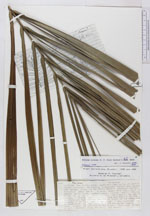
| Family | Arecaceae |
| Identification | Attalea colenda (O. F. Cook)H. Balslev & A. Henderson |
| Determined by | H. Balslev |
| Identification qualifier | |
| Field notes | A Palm about 25 m tall, with a smoot white trunk. Fruits borne in a large, dense raceme, individually on short stalks. Fronds are 7,0-10,4 m long and about 2 m wide. Leaflets are separate for the entire length of the frond and measure 1 m long and 7 cm wi |
| |
| This record has no coordinates. Display map with the 11 georeferenced records of Attalea colenda in the AAU Herbarium Database. |
| New Search Modify Search |