AAU Herbarium Database |
| New Search Modify Search |
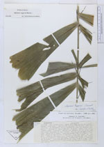
| Collector | Pearsall, D.M. |
| Number | 1070 |
| Collected with | |
| Country | Ecuador |
| Subpart | Manabi |
| County | |
| Locality | San Isidro area, upper Rio Jama vally of central Manabi province. Collecting between San Isidro and San Jacinto. In secondary forest formation near the Estero Capa perra |
| Coordinates | |
| Minimum elevation (m) | 300 |
| Maximum elevation (m) | 300 |
| Start date | 1982/04/11 |
| End date | 1982/04/11 |
| Family | Arecaceae |
| Identification | Aiphanes eggersii Burret |
| Determined by | F. Borchsenius & R. Bernal |
| Identification qualifier | |
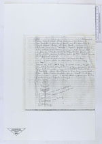
| Field notes | A palm, about 6 m tall. Spines are present on the trunk and under surfaces of the leaves. Fruits are bright pinkish red, borne on a loose, hanging raceme. Not in flower. The dry flesh of the fruits is edible, also the "meat" of the pit. Fruits are spherical |
| |
| This record has no coordinates. Display map with the 9 georeferenced records of Aiphanes eggersii in the AAU Herbarium Database. |
| New Search Modify Search |