AAU Herbarium Database |
| New Search Modify Search |
| Collector | Boufford, D.E. |
| Number | 21115 |
| Collected with | N. Foust |
| Country | USA |
| Subpart | West Virginia |
| County | |
| Locality | Brooke County: 3.7 km (2.9 miles) S of the junction of U.S. route 22E and W. Va. route 2 on route 2; along the Ohio River opposite the city of Steubenville, Ohio. Mixed deciduous forest of Quercus, Acer, Fraxinus, Robinia, ect. |
| Coordinates | |
| Minimum elevation (m) | 0 |
| Maximum elevation (m) | 0 |
| Start date | 1979/06/26 |
| End date | 1979/06/26 |
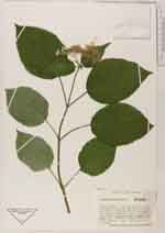
| Family | Hydrangeaceae |
| Identification | Hydrangea arborescens L. |
| Determined by | |
| Identification qualifier | |
| Field notes | Shrubs ca. 2 m tall |
| |
| This record has no coordinates. Display map with the 1 georeferenced records of Hydrangea arborescens in the AAU Herbarium Database. |
| New Search Modify Search |