| Locality | Dept. Huanuco, Prov. Pachitea, region of Pucallpa, western part of the "Sira mountains" and adjacent lowland; ca. 26 km S of Puerto Inca, next to the junction of the Rio Pachitea and Rio Yuyapichis, biological field station "Panguana" �Primary lowland rain forest with some xeromorphic elements, partly low, partly disturbed by local agriculture and logging. Soils: white sands or brown latosols with rocky outcrops. |
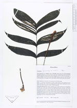
| Field notes | Habit: rhizomatous dwarf palm of the understory of 40-50cm heigth.�leaves: +/- 7-10 leaves; total length up to 80cm, usually trijugate, rarely splitting into more leaflets; sheaths: short, basally surrounding half the stem, distally splitting into fibres; petiole: up to 60cm long, green; rachis: 12-15cm long, green.�Inflorescence/infructescence: single, interfoliar, erect, spicate, monoeceous, protandrous; peduncle: up to 35cm long, dorsiventrally flattened, thin, green, bearing 2 peduncular bracts (5-10cm long); spike: 5-6cm long, markedly thicker than the peduncle, with a 0.5cm long sterile tip, green at anthesis; flowers: triads sunken in pits; male flowers with (yellowish-)green perianth and white stamina, female ones with green perianth and white staminodia and stigmas; fruit: mature fruit 6-7mm in diameter without stigmatic remain but with persisting dry, brown perianth; endocarp thin but woody, 5.5-6mm; black-violet, contrasting to the then orange peduncle and spike.� |