AAU Herbarium Database |
| New Search Modify Search |
| Collector | Heatubun, C.D. |
| Number | 343 |
| Collected with | Rudi A. Maturbongs, Matthias Sagisolo, Marthen J itrnau and Martinus taa. |
| Country | Indonesia |
| Subpart | Papua |
| County | |
| Locality | Nabire, Samabusa. Swamp to lowland rain fore st. |
| Coordinates | |
| Minimum elevation (m) | 10 |
| Maximum elevation (m) | 10 |
| Start date | 2001/02/10 |
| End date | 2001/02/10 |
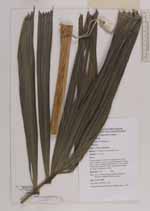
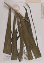
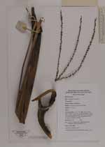
| Family | Arecaceae |
| Identification | Hydriastele |
| Determined by | Charlie D. Heatubun |
| Identification qualifier | |
| Field notes | Clustering palm; tall to 10 m high; stem 5 cm in diam.; Leaves 8 in crown, spirally arranged, 150 cm long, 15 pairs leaflets, petiole 30-50 cm, crownshaft 75 cm long, sheath 50-75 cm; Inflorescence horse tail shape, pendulous rachilla. |
| |
| This record has no coordinates. Display map with the 9 georeferenced records of Hydriastele in the AAU Herbarium Database. |
| New Search Modify Search |