AAU Herbarium Database |
| New Search Modify Search |
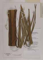
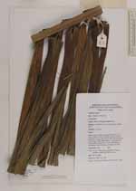
| Collector | Heatubun, C.D. |
| Number | 340 |
| Collected with | Rudi A. Maturbongs, Matthias Sagisolo, Marthen Jittnau and Martinus taa. |
| Country | Indonesia |
| Subpart | Papua |
| County | |
| Locality | Nabire, Wanggar, Bumi river. Secondary forest in old garden, swamp forest. |
| Coordinates | |
| Minimum elevation (m) | 10 |
| Maximum elevation (m) | 10 |
| Start date | 2001/02/09 |
| End date | 2001/02/09 |
| Family | Arecaceae |
| Identification | Hydriastele costata F.M.Bailey |
| Determined by | |
| Identification qualifier | |
| Field notes | Solitary palm; tall to 25 m high; stem 30 cm in diam.; Leaves 17·18 in crown, spirally arranged, 350-450 cm long, 100-150 cm wide, petiole short to 10 cm long, 58·60 pairs leaflets, crownshaft 150-200 cm long, sheat 150 x 75 cm; Inflorescence infrafoliar, horse tail shape, pendolous rachilla. |

| |
| This record has no coordinates. Display map with the 2 georeferenced records of Hydriastele costata in the AAU Herbarium Database. |
| New Search Modify Search |