| Collector | Berg, C. C. |
| Number | 699 |
| Collected with | Silva, A.S.; Nelson, B.W.; Henderson, A.J.; Bahia, R.P.; Santos, M.R. |
| Country | Brazil |
| Subpart | Pará |
| County | |
| Locality | 1-2 km NE of Repartimento (ca. 140 km on the road Marabá-Altamira). Forest on terra firme. |
| Coordinates | 4° 14' 25.98'' S 49° 56' 22.13'' W |
| Minimum elevation (m) | 0 |
| Maximum elevation (m) | 0 |
| Start date | 1977/10/24 |
| End date | 1977/10/24 |
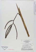
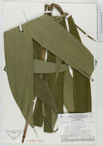
| Family | Arecaceae |
| Identification | Geonoma baculifera (Poit.)Kunth |
| Determined by | Henderson, A. |
| Identification qualifier | |
| Field notes | Treelet up to 3 cm high; lamina 85 cn long, undivided or divided into up to 5 segments; petiole 35 - 60 cm; flowers pink, fruits black. |
|
 Other records of Geonoma baculifera