AAU Herbarium Database |
| New Search Modify Search |
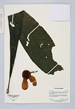
| Collector | Staahl, B. |
| Number | 3959 |
| Collected with | J.T.Knudsen |
| Country | Ecuador |
| Subpart | Napo |
| County | |
| Locality | Tiputini Biodiversity Station on río tiputini. Ca. 25 km S of Panacocha. Primary, terra firme forest. |
| Coordinates | 0° 38' S 76° 9' W |
| Minimum elevation (m) | 200 |
| Maximum elevation (m) | 200 |
| Start date | 1997/01/21 |
| End date | 1997/01/21 |
| Family | Lecythidaceae |
| Identification | Gustavia |
| Determined by | |
| Identification qualifier | |
| Field notes | Tree 9 m. Leaves apically clustered. Flowers white sweet, gerianiolic scent, petals purple, pale purple at abse, lower 2/3 of filaments cream, upper 1/3 purple. Anthers yelow. |
| |
 Other records of Gustavia Other records of GustaviaThe map displays only records from the Aarhus Herbarium Database. The records may not represent the full distribution of Gustavia |
| New Search Modify Search |