| Collector | Staahl, B. |
| Number | 2982 |
| Collected with | J.T. Knudsen |
| Country | Ecuador |
| Subpart | Napo |
| County | |
| Locality | The Yasuní Biological Station on Rio Tiputini, ca 35 km by air SE of Pompeya. Primary terra firme forest ("Ceiba trail"). |
| Coordinates | 0° 40' S 76° 23' W |
| Minimum elevation (m) | 200 |
| Maximum elevation (m) | 300 |
| Start date | 1996/09/18 |
| End date | 1996/09/18 |
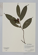
| Family | Annonaceae |
| Identification | Cremastosperma gracilipes R.E. Fries |
| Determined by | Paul Maas |
| Identification qualifier | |
| Field notes | Shrup 1.5 m, mericarps pinkish red. |
|
 Other records of Cremastosperma gracilipes