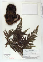
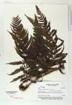
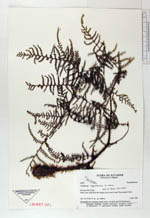
| Collector | Ollgaard, B. |
| Number | 99837 |
| Collected with | |
| Country | Ecuador |
| Subpart | PASTAZA |
| County | |
| Locality | Road to the south from Río Negro, km 9, end of road. Wet montane forest. |
| Coordinates | 0° 27' S 78° 13' W |
| Minimum elevation (m) | 1800 |
| Maximum elevation (m) | 1800 |
| Start date | 1992/03/05 |
| End date | 1992/03/05 |
| Family | Dryopteridaceae |
| Identification | Polybotrya aequatoriana R. C. Moran |
| Determined by | Moran, R.C. (AAU), 1993. |
| Identification qualifier | |
| Field notes | Hemiepiphyte in clearing, rosette with c. 10 sterile and 10 fertile leaves. |
|
 Other records of Polybotrya aequatoriana