AAU Herbarium Database |
| New Search Modify Search |
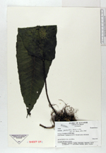
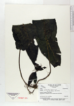
| Collector | Ollgaard, B. |
| Number | 99800 |
| Collected with | Navarrete, H. |
| Country | Ecuador |
| Subpart | ZAMORA-CHINCHIPE |
| County | |
| Locality | Road Zamora-Gualaquiza, km 30. Forested ravine with stream. |
| Coordinates | 3° 53' S 78° 48' W |
| Minimum elevation (m) | 900 |
| Maximum elevation (m) | 900 |
| Start date | 1992/03/03 |
| End date | 1992/03/03 |
| Family | Dryopteridaceae |
| Identification | Bolbitis pandurifolia (Hook.) C. Chr. |
| Determined by | Moran, R.C. (AAU), 1993. |
| Identification qualifier | |
| Field notes | On banks and rocks at stream. |
| |
 Other records of Bolbitis pandurifolia Other records of Bolbitis pandurifoliaThe map displays only records from the Aarhus Herbarium Database. The records may not represent the full distribution of Bolbitis pandurifolia |
| New Search Modify Search |