AAU Herbarium Database |
| New Search Modify Search |
| Collector | Ollgaard, B. |
| Number | 99639 |
| Collected with | |
| Country | Ecuador |
| Subpart | PASTAZA |
| County | |
| Locality | Road N of El Topo (Rio Negro-Mera), km ca. 9. Montane forest at creek. |
| Coordinates | 1° 21' S 78° 12' W |
| Minimum elevation (m) | 1450 |
| Maximum elevation (m) | 1450 |
| Start date | 1992/01/23 |
| End date | 1992/01/23 |
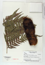
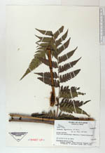
| Family | Dryopteridaceae |
| Identification | Polybotrya aequatoriana R. C. Moran |
| Determined by | Moran, R.C. (AAU), 1993. |
| Identification qualifier | |
| Field notes | Hemiepiphyte, leaves to 1 m long. |
| |
 Other records of Polybotrya aequatoriana Other records of Polybotrya aequatorianaThe map displays only records from the Aarhus Herbarium Database. The records may not represent the full distribution of Polybotrya aequatoriana |
| New Search Modify Search |