AAU Herbarium Database |
| New Search Modify Search |
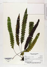
| Collector | Ollgaard, B. |
| Number | 99626 |
| Collected with | |
| Country | Ecuador |
| Subpart | PASTAZA |
| County | |
| Locality | Road N of El Topo (Rio Negro-Mera), km ca. 10 (end of road). Montane forest at Río Topo. |
| Coordinates | 1° 21' S 78° 12' W |
| Minimum elevation (m) | 1400 |
| Maximum elevation (m) | 1400 |
| Start date | 1992/01/23 |
| End date | 1992/01/23 |
| Family | Grammitidaceae |
| Identification | Grammitis trifurcata (L.)Copel. |
| Determined by | B. Ollgaard 1992 |
| Identification qualifier | |
| Field notes | On shaded rock face at stream. |
| |
 Other records of Grammitis trifurcata Other records of Grammitis trifurcataThe map displays only records from the Aarhus Herbarium Database. The records may not represent the full distribution of Grammitis trifurcata |
| New Search Modify Search |