AAU Herbarium Database |
| New Search Modify Search |
| Collector | Ollgaard, B. |
| Number | 99228 |
| Collected with | Bergmann, B. & Ruíz, M. |
| Country | Ecuador |
| Subpart | ZAMORA-CHINCHIPE |
| County | |
| Locality | Miazi, at junction of Río Chumbiriatza with Río Nangaritza. Tall montane forest, riverside forest, riverbanks, dwarfed mossy ridgetop forest and calcareous rocks. |
| Coordinates | 4° 19' S 78° 40' W |
| Minimum elevation (m) | 1200 |
| Maximum elevation (m) | 950 |
| Start date | 1991/10/21 |
| End date | 1991/10/23 |
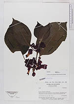
| Family | Gesneriaceae |
| Identification | Drymonia |
| Determined by | John L. Clark |
| Identification qualifier | |
| Field notes | Calyx dark purple, corolla white, purple at tip. |
| |
| Display all 46 georeferenced records of Drymonia Drymonia |
| New Search Modify Search |