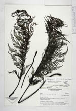
| Collector | Ollgaard, B. |
| Number | 99094 |
| Collected with | |
| Country | Ecuador |
| Subpart | PICHINCHA |
| County | |
| Locality | Road Toachi-San Francisco de Pampas, ca. 1 km SW of Paloquemado. Disturbed remnants of montane forest. |
| Coordinates | 0° 23' S 78° 56' W |
| Minimum elevation (m) | 1430 |
| Maximum elevation (m) | 1430 |
| Start date | 1991/07/29 |
| End date | 1991/07/29 |
| Family | Pteridaceae |
| Identification | Pityrogramma ochracea (C.Presl)Domin |
| Determined by | Moran, R.C. (AAU), 1993. |
| Identification qualifier | |
| Field notes | Var. ochracea (Presl) Tryon. Road bank c. 2 km S of Palo Quemado. |
|
 Other records of Pityrogramma ochracea