AAU Herbarium Database |
| New Search Modify Search |
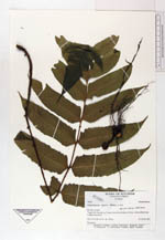
| Collector | Ollgaard, B. |
| Number | 99062 |
| Collected with | Blasco, M. |
| Country | Ecuador |
| Subpart | NAPO |
| County | |
| Locality | "Upper Río Tiputini, ca. 2 canoe-hours from bridge on Coca-Auca-oilfield road. Tropical rain forest." |
| Coordinates | 0° 43' S 76° 57' W |
| Minimum elevation (m) | 300 |
| Maximum elevation (m) | 300 |
| Start date | 1991/07/21 |
| End date | 1991/07/23 |
| Family | Dryopteridaceae |
| Identification | Stigmatopteris opaca (Bak.)C. Chr. |
| Determined by | Moran, R.C. (AAU), 1993. |
| Identification qualifier | |
| Field notes | Terrestrial. |
| |
 Other records of Stigmatopteris opaca Other records of Stigmatopteris opacaThe map displays only records from the Aarhus Herbarium Database. The records may not represent the full distribution of Stigmatopteris opaca |
| New Search Modify Search |