| Collector | Ollgaard, B. |
| Number | 98754 |
| Collected with | Korning, J. & Krogstrup, K. |
| Country | Ecuador |
| Subpart | ESMERALDAS |
| County | |
| Locality | Road Lita-Alto Tambo, km 18. Perhumid forest on plateau. |
| Coordinates | 0° 47' N 78° 30' W |
| Minimum elevation (m) | 900 |
| Maximum elevation (m) | 900 |
| Start date | 1991/01/13 |
| End date | 1991/01/13 |
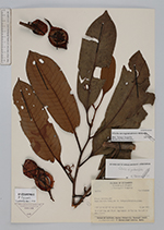
| Family | Myristicaceae |
| Identification | Otoba novogranatensis Moldenke |
| Determined by | Jaramillo, T. (AAU), 1999. |
| Identification qualifier | |
| Field notes | 30 m tall tree, dbh 35 cm. Sap reddish. Arillus red. Box coll. in AAU (fruits). |
|
 Other records of Otoba novogranatensis