AAU Herbarium Database |
| New Search Modify Search |
| Collector | Ollgaard, B. |
| Number | 9857 |
| Collected with | Balslev, H. |
| Country | Ecuador |
| Subpart | COTOPAXI |
| County | |
| Locality | Near origin of Rio Langoa, E of Latacunga (Laguna Salayambo Cocha). Heavily grazed páramo with boggy depressions, small lakes and steep rocky escarpments. |
| Coordinates | 0° 56' S 78° 25' W |
| Minimum elevation (m) | 3800 |
| Maximum elevation (m) | 4050 |
| Start date | 1976/09/30 |
| End date | 1976/09/30 |
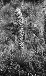
| Family | Bromeliaceae |
| Identification | Puya clava-herculis Mez & Sodiro |
| Determined by | H. Luther (SEL), 1990. |
| Identification qualifier | |
| Field notes | On a humid slope. Plant ca. 1 m high. Flowers greenish- blue. "Achupalla" (means Bears food). |
| |
 Other records of Puya clava-herculis Other records of Puya clava-herculisThe map displays only records from the Aarhus Herbarium Database. The records may not represent the full distribution of Puya clava-herculis |
| New Search Modify Search |