AAU Herbarium Database |
| New Search Modify Search |
| Collector | Ollgaard, B. |
| Number | 98320 |
| Collected with | |
| Country | Ecuador |
| Subpart | ZAMORA-CHINCHIPE |
| County | |
| Locality | "Cordillera del Condor; trail from Patchicutza along quebrada Patchicutza towards 'el hito' (linea de facto) on the cordillera. Wet montane forest." |
| Coordinates | 4° 7' S 78° 32' W |
| Minimum elevation (m) | 1450 |
| Maximum elevation (m) | 850 |
| Start date | 1990/12/04 |
| End date | 1990/12/04 |
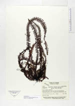
| Family | Grammitidaceae |
| Identification | Terpsichore communis Moguel |
| Determined by | Moguel,A.L. |
| Identification qualifier | |
| Field notes | Epiphyte in shade. |
| |
 Other records of Terpsichore communis Other records of Terpsichore communisThe map displays only records from the Aarhus Herbarium Database. The records may not represent the full distribution of Terpsichore communis |
| New Search Modify Search |