AAU Herbarium Database |
| New Search Modify Search |
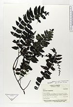
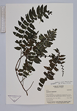
| Collector | Ollgaard, B. |
| Number | 98074 |
| Collected with | |
| Country | Ecuador |
| Subpart | PICHINCHA |
| County | |
| Locality | C. km 36 along road to the southeast from La Aurora (km 7 on Sto. Domingo-Quevedo road), passing through La Reforma. Remnants of dense, tall cloud forest. |
| Coordinates | 0° 28' S 79° 8' W |
| Minimum elevation (m) | 1450 |
| Maximum elevation (m) | 1450 |
| Start date | 1990/07/24 |
| End date | 1990/07/24 |
| Family | Aspleniaceae |
| Identification | Asplenium volubile Murak.& Moran |
| Determined by | Moran, R.C. (AAU), 1993. |
| Identification qualifier | |
| Field notes | Climbing epiphyte. |
| |
 Other records of Asplenium volubile Other records of Asplenium volubileThe map displays only records from the Aarhus Herbarium Database. The records may not represent the full distribution of Asplenium volubile |
| New Search Modify Search |