AAU Herbarium Database |
| New Search Modify Search |
| Collector | Ollgaard, B. |
| Number | 98050 |
| Collected with | |
| Country | Ecuador |
| Subpart | PICHINCHA |
| County | |
| Locality | C. km 8 along road to the southeast from La Aurora (km 7 on Sto. Domingo-Quevedo road), at bridge over Río Baba. Steep, shaded, moist rock face along river, and rocky river banks. |
| Coordinates | 0° 21' S 79° 13' W |
| Minimum elevation (m) | 500 |
| Maximum elevation (m) | 500 |
| Start date | 1990/07/24 |
| End date | 1990/07/24 |
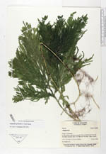
| Family | Selaginellaceae |
| Identification | Selaginella geniculata (C. Presl)Spring |
| Determined by | Valdespino, I.A. (NY), 1995. |
| Identification qualifier | |
| Field notes | On shaded rocks.. |
| |
| Display all 29 georeferenced records of Selaginella Selaginella geniculata |
| New Search Modify Search |