AAU Herbarium Database |
| New Search Modify Search |
| Collector | Ollgaard, B. |
| Number | 98041 |
| Collected with | |
| Country | Ecuador |
| Subpart | NAPO |
| County | |
| Locality | Road Cotundo-Loreto, c. 38 km from junction with road Baeza-Tena. Tall, wet montane forest. |
| Coordinates | 0° 53' S 77° 39' W |
| Minimum elevation (m) | 1250 |
| Maximum elevation (m) | 1250 |
| Start date | 1990/07/18 |
| End date | 1990/07/18 |
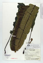
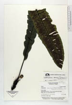
| Family | Dryopteridaceae |
| Identification | Diplazium aberrans Maxon & C. V. Morton |
| Determined by | Pacheco, L. (UAMIZ), 1992. |
| Identification qualifier | |
| Field notes | Terrestrial, in deep shade. |
| |
 Other records of Diplazium aberrans Other records of Diplazium aberransThe map displays only records from the Aarhus Herbarium Database. The records may not represent the full distribution of Diplazium aberrans |
| New Search Modify Search |