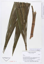
| Collector | Ollgaard, B. |
| Number | 91064 |
| Collected with | |
| Country | Ecuador |
| Subpart | ZAMORA-CHINCHIPE |
| County | |
| Locality | Parque Nacional Podocarpus. Road Yangana-Valladolid, just S and E of the pass (Nudo de Sabanilla). Muletrack from pass toward Quebrada Honda. |
| Coordinates | 4° 27' S 78° 8' W |
| Minimum elevation (m) | 2750 |
| Maximum elevation (m) | 2950 |
| Start date | 1989/03/14 |
| End date | 1989/03/14 |
| Family | Arecaceae |
| Identification | Geonoma densa Linden & H. Wendl. |
| Determined by | Borchsenius, F. (AAU), 1996. |
| Identification qualifier | |
| Field notes | 3 m tall, stem c. 4 cm thick. Leaves hard, plicate. |
|
 Other records of Geonoma densa