| Collector | Ollgaard, B. |
| Number | 8738 |
| Collected with | Balslev, H. |
| Country | Ecuador |
| Subpart | IMBABURA |
| County | |
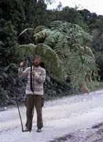
| Locality | Road Cotacachi - Apuela, 33-36 km from Cotacachi (Intac valley). Road banks and montane forest. |
| Coordinates | 0° 20' N 78° 26' W |
| Minimum elevation (m) | 2900 |
| Maximum elevation (m) | 2950 |
| Start date | 1976/08/11 |
| End date | 1976/08/11 |
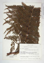
| Family | Lophosoriaceae |
| Identification | Lophosoria quadripinnata var. quadripinnata (Gmel.) C. Chr. |
| Determined by | A. Tryon & J. Hickey, 1979 |
| Identification qualifier | |
| Field notes | Rhizome short, fronds 4.5 m long. Stipe ca. 2 m long, with rusty brown hairs. |
|
 Other records of Lophosoria quadripinnata var. quadripinnata