AAU Herbarium Database |
| New Search Modify Search |
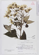
| Collector | Ollgaard, B. |
| Number | 8719 |
| Collected with | Balslev, H. |
| Country | Ecuador |
| Subpart | IMBABURA |
| County | |
| Locality | Road Cotacachi - Apuela, 33-36 km from Cotacachi (Intac valley). Road banks and montane forest. |
| Coordinates | 0° 20' N 78° 26' W |
| Minimum elevation (m) | 2900 |
| Maximum elevation (m) | 2950 |
| Start date | 1976/08/11 |
| End date | 1976/08/11 |
| Family | Asteraceae |
| Identification | Munnozia senecionidis Benth. |
| Determined by | Robinson,H. |
| Identification qualifier | |
| Field notes | Scandent shrub. |
| |
| Display all 44 georeferenced records of Munnozia Munnozia senecionidis |
| New Search Modify Search |