AAU Herbarium Database |
| New Search Modify Search |
| Collector | Ollgaard, B. |
| Number | 8152 |
| Collected with | Balslev, H. |
| Country | Ecuador |
| Subpart | NAPO |
| County | |
| Locality | Road Quito-Baeza, 7-8 km NW of Laguna de Papallacta (Páramo de Guamaní). Flat boggy depression, adjacent bunch grass páramo and Polylepis-forest. |
| Coordinates | 0° 19' S 78° 8' W |
| Minimum elevation (m) | 3800 |
| Maximum elevation (m) | 3800 |
| Start date | 1976/07/20 |
| End date | 1976/07/20 |
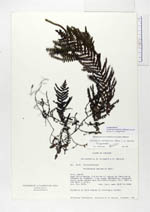
| Family | Grammitidaceae |
| Identification | Terpsichore monosora Moguel |
| Determined by | Moguel,A.L. |
| Identification qualifier | |
| Field notes | Epiphyte in dark places in Polylepis forest. |
| |
 Other records of Terpsichore monosora Other records of Terpsichore monosoraThe map displays only records from the Aarhus Herbarium Database. The records may not represent the full distribution of Terpsichore monosora |
| New Search Modify Search |