| Collector | Ollgaard, B. |
| Number | 8144 |
| Collected with | Balslev, H. |
| Country | Ecuador |
| Subpart | NAPO |
| County | |
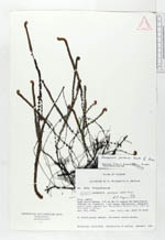
| Locality | Road Quito-Baeza, 7-8 km NW of Laguna de Papallacta (Páramo de Guamaní). Flat boggy depression, adjacent bunch grass páramo and Polylepis-forest. |
| Coordinates | 0° 19' S 78° 8' W |
| Minimum elevation (m) | 3800 |
| Maximum elevation (m) | 3800 |
| Start date | 1976/07/20 |
| End date | 1976/07/20 |
| Family | Pteridaceae |
| Identification | Jamesonia pulchra Hook. & Grev. |
| Determined by | Arbelaez, A. L. (MO), 2000. |
| Identification qualifier | |
| Field notes | In bunch-grass páramo. Rhizomes subterranean. |
|
 Other records of Jamesonia pulchra