AAU Herbarium Database |
| New Search Modify Search |
| Collector | Ollgaard, B. |
| Number | 8010 |
| Collected with | Balslev, H. |
| Country | Ecuador |
| Subpart | NAPO |
| County | |
| Locality | Road Quito-Baeza, at Laguna de Papallacta. Montane forest with grazed pastures in clearings, W of the lake. |
| Coordinates | 0° 21' S 78° 6' W |
| Minimum elevation (m) | 3350 |
| Maximum elevation (m) | 3350 |
| Start date | 1976/07/17 |
| End date | 1976/07/17 |
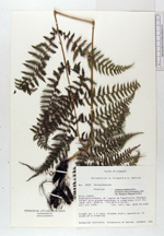
| Family | Dryopteridaceae |
| Identification | Athyrium dombeyi Desv. |
| Determined by | Øllgaard,B. |
| Identification qualifier | |
| Field notes | Fronds ca. 1 m long. Rhizome short, ascending. In shade at a clearing. |
| |
 Other records of Athyrium dombeyi Other records of Athyrium dombeyiThe map displays only records from the Aarhus Herbarium Database. The records may not represent the full distribution of Athyrium dombeyi |
| New Search Modify Search |