AAU Herbarium Database |
| New Search Modify Search |
| Collector | Ollgaard, B. |
| Number | 74647 |
| Collected with | |
| Country | Ecuador |
| Subpart | LOJA |
| County | |
| Locality | Parque Nacional Podocarpus. E of Nudo de Cajanuma, trail E of 'Centro de Informacion' to crest on trail to Lagunas de Compadre. |
| Coordinates | 4° 5' S 79° 10' W |
| Minimum elevation (m) | 2850 |
| Maximum elevation (m) | 3050 |
| Start date | 1984/06/06 |
| End date | 1984/06/06 |
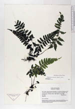
| Family | Dryopteridaceae |
| Identification | Diplazium sprucei (Baker) C. Chr. |
| Determined by | Stolze, R.G. (F), 1992. |
| Identification qualifier | |
| Field notes | On wet trail bank. |
| |
 Other records of Diplazium sprucei Other records of Diplazium spruceiThe map displays only records from the Aarhus Herbarium Database. The records may not represent the full distribution of Diplazium sprucei |
| New Search Modify Search |