| Collector | Ollgaard, B. |
| Number | 58485 |
| Collected with | Laegaard, S. & Thomsen, K. & Korning, J. & Illum, T. |
| Country | Ecuador |
| Subpart | ZAMORA-CHINCHIPE |
| County | |
| Locality | Parque Nacional Podocarpus, just E of the pass on road Loja - Zamora. Old mule trail, elfin forest and open boggy areas. |
| Coordinates | 3° 59' S 79° 9' W |
| Minimum elevation (m) | 2800 |
| Maximum elevation (m) | 2900 |
| Start date | 1985/03/01 |
| End date | 1985/03/01 |
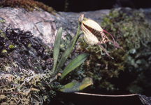
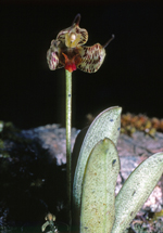
| Family | Orchidaceae |
| Identification | Masdevallia picturata Rchb. f. |
| Determined by | C. Luer (MO), 1991. |
| Identification qualifier | |
| Field notes | Epiphyte. Outer tepals pale green with dark purple spots, inside with orange-brown dot at base. Labium purplish tinged. Photo: K.Thomsen |
|
 Other records of Masdevallia picturata