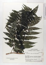
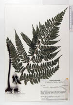
| Collector | Ollgaard, B. |
| Number | 35130 |
| Collected with | Asanza, E. & Brandbyge, J. & Roth, S. & Sperling, C. |
| Country | Ecuador |
| Subpart | PASTAZA |
| County | |
| Locality | Río Capihuari, tributary of Río Pastaza. Inundated forest, black water swamp, and forest on elevated ground. |
| Coordinates | 2° 30' S 76° 50' W |
| Minimum elevation (m) | 285 |
| Maximum elevation (m) | 285 |
| Start date | 1980/07/23 |
| End date | 1980/07/23 |
| Family | Dennstaedtiaceae |
| Identification | Dennstaedtia bipinnata (Cav.)Maxon |
| Determined by | Ollgaard, B. (AAU), 2000. |
| Identification qualifier | |
| Field notes | Rhizome short, creeping on forest floor. Fronds 1.8 m high. Lamina broadly triangular. |
|
 Other records of Dennstaedtia bipinnata