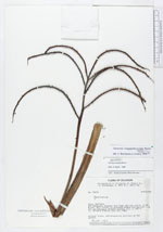
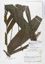
| Collector | Ollgaard, B. |
| Number | 34754 |
| Collected with | Asanza, E. & Brandbyge, J. & Roth, S. & Sperling, C. |
| Country | Ecuador |
| Subpart | PASTAZA |
| County | |
| Locality | Río Bobonaza, between Cachitama and the outlet of Río Bufeo. Rain forest on elevated ground and adjacent low and periodically flooded ground. |
| Coordinates | 2° 20' S 76° 40' W |
| Minimum elevation (m) | 300 |
| Maximum elevation (m) | 300 |
| Start date | 1980/07/19 |
| End date | 1980/07/19 |
| Family | Arecaceae |
| Identification | Geonoma longepedunculata Burret |
| Determined by | Borchsenius, F. (AAU), 1996. |
| Identification qualifier | |
| Field notes | Without trunk. Inflorescences axillary at the ground. |
|
 Other records of Geonoma longepedunculata