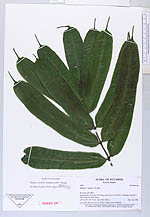
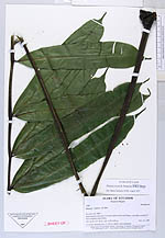
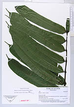
| Collector | Ollgaard, B. |
| Number | 2089 |
| Collected with | |
| Country | Ecuador |
| Subpart | EL ORO |
| County | |
| Locality | Sambotambo road, km 4-5.5 from intersection with Piñas-Arenillas road km 9. Tall evergreen slope forest. |
| Coordinates | 3° 38' S 79° 44' W |
| Minimum elevation (m) | 1130 |
| Maximum elevation (m) | 1230 |
| Start date | 1996/11/19 |
| End date | 1996/11/19 |
| Family | Marattiaceae |
| Identification | Danaea erecta Tuomisto & R.C.Moran |
| Determined by | H. Turmisto & J. Keskiniva |
| Identification qualifier | |
| Field notes | 1.5 m tall, rhizome erect, to 30 cm, radial, roots unilateral. |
|
 Other records of Danaea erecta