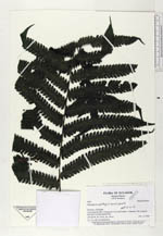
| Collector | Ollgaard, B. |
| Number | 2059 |
| Collected with | H. Navarrete |
| Country | Ecuador |
| Subpart | LOS RIOS |
| County | |
| Locality | Cerro Samama (Hda. Clementina), S of road Caluma-Catarama. Tall evergreen dry forest at Destacamento Pita. |
| Coordinates | 1° 40' S 79° 20' W |
| Minimum elevation (m) | 450 |
| Maximum elevation (m) | 450 |
| Start date | 1996/11/14 |
| End date | 1996/11/14 |
| Family | Thelypteridaceae |
| Identification | Thelypteris biolleyi (Christ.) Proctor |
| Determined by | Navarrete, H. (AAU), 1998. |
| Identification qualifier | |
| Field notes | To 1.2 m tall, dry forest floor. |
|
 Other records of Thelypteris biolleyi