AAU Herbarium Database |
| New Search Modify Search |
| Collector | Ollgaard, B. |
| Number | 2055 |
| Collected with | H. Navarrete |
| Country | Ecuador |
| Subpart | LOS RIOS |
| County | |
| Locality | Summit of Cerro Samama (Hda. Clementina), S of road Caluma-Catarama. Tall cloud forest on slope. |
| Coordinates | 1° 40' S 79° 19' W |
| Minimum elevation (m) | 700 |
| Maximum elevation (m) | 730 |
| Start date | 1996/11/13 |
| End date | 1996/11/14 |
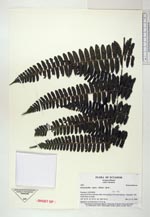
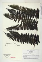
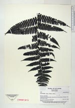
| Family | Dennstaedtiaceae |
| Identification | Dennstaedtia vagans (Baker) Diels |
| Determined by | |
| Identification qualifier | |
| Field notes | Epiphytic in cloud forest, to 4 m up. |

| |
 Other records of Dennstaedtia vagans Other records of Dennstaedtia vagansThe map displays only records from the Aarhus Herbarium Database. The records may not represent the full distribution of Dennstaedtia vagans |
| New Search Modify Search |